
The evolution of drone technology has revolutionized how businesses and industries gather critical data. One of the most powerful advancements is thermal aerial photography, which uses infrared drone imaging to detect heat variations invisible to the human eye. Whether it’s thermal inspections for buildings, agriculture monitoring, or firefighting applications, the ability to capture heat signatures from the air enhances efficiency, safety, and cost savings across multiple sectors.
Key Benefits of Thermal Aerial Photography
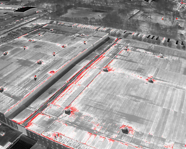
1. Roof and Building Inspections with Thermal Drones
Thermal drone photography allows for quick and precise building envelope inspections, detecting heat loss, moisture intrusion, and insulation issues. Property managers, roofing contractors, and energy auditors can use infrared imaging to identify problems early, preventing costly structural damage.
2. Search and Rescue with Infrared Drone Imaging
In emergency response situations, thermal search and rescue drones can locate missing persons by detecting body heat signatures. Whether in dense forests, disaster zones, or nighttime operations, thermal drone technology improves the speed and success rate of rescue missions.
3. Precision Agriculture with Thermal Drone Mapping
Farmers and agronomists can leverage thermal aerial imaging for crop health analysis, irrigation system monitoring, and livestock tracking. By identifying water stress, pest infestations, or diseased crops early, infrared drone photography helps optimize yields and reduce resource waste.
4. Utility and Infrastructure Inspections Using Thermal Imaging Drones
Power lines, pipelines, and industrial equipment require regular inspections. Thermal drone inspections can detect overheating electrical components, leaks in pipelines, and structural weaknesses before they lead to failures. This proactive approach helps prevent power outages, costly repairs, and safety hazards.
5. Firefighting and Hotspot Detection with Thermal Drone Photography
Fire departments and wildfire response teams rely on thermal aerial imaging to identify hidden hotspots, track fire spread, and enhance overall firefighting strategies. Infrared drone cameras provide real-time data to improve situational awareness and firefighter safety.
6. Environmental and Wildlife Monitoring
From tracking animal populations to detecting poaching activities, thermal imaging drones offer a non-invasive way to monitor ecosystems and conservation areas. Researchers can also use thermal cameras to study habitat changes, migration patterns, and environmental conditions.
Why Bender Drone Services is Your Best Choice for Thermal Aerial Imaging
At Bender Drone Services, we utilize state-of-the-art thermal drones to deliver high-resolution infrared imaging tailored to your industry needs. Whether you require thermal property inspections, agricultural monitoring, utility assessments, or emergency response support, our experienced pilots provide precise, efficient, and actionable data.